Persistent Location Tracking: Picking The Right Tool
In this post, I compare Google Latitude and InstaMapper, two popular services for persistent location tracking. I walk through installation and data extraction via API for each service, then provide some subjective first impressions as to which one better suits my location-tracking needs.
Evaluating Tools #
As the ecosystem of self-tracking tools grows exponentially, choosing the right tool is becoming an increasingly daunting task. To add to the complexity of this decision, self-tracking tools are highly personal.
How do I pick the best tool for me?
This question is far from monolithic:
- Do I want manual or automatic tracking?
- How much time and effort am I willing to spend on self-tracking?
- Is a hybrid automatic plus manual annotation approach workable?
- Do I want persistent tracking?
- All day? Or only at predetermined times?
- Every day? What if I'm on vacation?
- Do I want raw data access?
- How do I want to access that data? Through Excel CSV files? Via a developer-friendly API?
- What granularity do I want? Sub-second? Daily?
- What parameters do I want? For location, is
(lat, long)enough? Do I want altitude as well? GPS fix accuracy?
Without a searchable database of self-tracking tools, these questions can be difficult to answer. The main Quantified Self website includes a Guide to Self-Tracking Tools, but their implementation is subject to criticism:
In a report to RWJF, Project Director Alexandra C. Carmichael noted that the guide was more a catalog of tools than a useful manual for people wanting to choose and use these tools.
This is a point worth repeating. Simply listing tools is not enough; a database of tools must answer these basic questions to be useful. A quick search on the Guide for location-related tools comes up short:

Why is MoodPanda listed? I suppose it must location-tag mood entries, but that isn't made explicit in the description. Momento makes a bit more sense, but it's primarily a journalling app. Foursquare is definitely location-based, but anyone unfamiliar with it must read its description closely to realize that it relies on manual check-ins.
In lieu of a useful tool database, the only effective option is direct evaluation. By investigating two popular location tracking tools, I'll demonstrate how such an evaluation might be carried out.
The Tools #
Google Latitude #
Google Latitude bills itself primarily as a social location sharing service:

Social capacities aside, the Location History functionality can be used as a persistent location-tracking tool.
InstaMapper #
I first heard of InstaMapper from Ted Power's talk on geo-tracking. Unlike Google Latitude, InstaMapper focuses more on personal tracking:

The Criteria #
My ideal location tracking tool is:
- Android-compatible: It should work with my RAZR M running Android 4.0.4 (Ice Cream Sandwich).
- Battery-friendly: It should allow me to go at least a day without recharging.
- Automatic: It should track my location without requiring check-ins or other manual input.
- Persistent: It should track my location constantly.
- Fine-grained: It should be capable of per-minute resolution or better.
- Developer-friendly: It should provide an API for fetching location history, and the data offered through that API should be as complete as possible.
Both tools are Android-compatible, automatic, and persistent already, which narrows down the list of criteria to evaluate.
Installation #
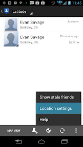
Google Latitude #
Enabling automatic location tracking on Android requires only a single setting change:


InstaMapper #
I followed the Android installation directions here. After you register for an InstaMapper account, you install InstaMapper's GPS Tracker app:

Comparison #
Both tools are easily installed, but Google Latitude wins on simplicity. This is unsurprising, as Google Latitude comes pre-installed.
Data Export #
Google Latitude #
To export data from the Location History dashboard, click on Export KML under the calendar widget:

InstaMapper #
Head to the data page for your device:


Here's where this process gets weird. To export your data, you first have to define a track:


Once the track is created, you can visit the Track Manager to export your track data in a variety of formats:


Comparison #
This one goes to Google Latitude. Aside from the terrible UI flow, InstaMapper has some other problems:
- The
accuracyfield is missing, making it harder to filter out noisy readings. - As stated in the InstaMapper FAQ, data access is limited to the previous 30 days or 100 000 locations.
API Fetching #
Tailers and Streams #
Many real-time APIs provide REST endpoints for fetching time-bounded chunks of data, such as
https://www.googleapis.com/latitude/v1/location?key=INSERT-YOUR-KEY&min-time=1111&max-time=2222&max-results=10.
By keeping track of a since time to fetch after, we can easily turn this into a stream:
def request(since):
  # TODO: actually fetch data
  pass

def sleep(since, freq):
  elapsed = time.time() - since
  wait = freq - elapsed
  if wait < 0:
    return
  time.sleep(wait)

def poll(freq):
  since = time.time()
  while True:
    sleep(since, freq)
    locations = request(since)
    if not locations:
      continue
    doSomething(locations)
    since = locations[-1].timestamp
This pattern is often referred to as a tailer. Why? Suppose we have a simple implementation of doSomething():
def doSomething(locations):
  for location in locations:
    print location
This prints out locations as they are received, similar to UNIX tail -F. By adjusting freq I can make different real-time guarantees, although at some point the upstream API will start throttling my requests.
Google Latitude #
You can see a working tailer implementation here.
To access the Google Latitude API, you first need to register an application. This gives you the necessary parameters YOUR_KEY, YOUR_SECRET for stepping through the OAuth flow.
With the Python library oauthclient2, retrieving OAuth credentials is relatively painless:
from oauth2client.client import OAuth2WebServerFlow
from oauth2client.file import Storage
from oauth2client.tools import run

def getCredentials(key, secret):
  flow = OAuth2WebServerFlow(
    client_id=key,
    client_secret=secret,
    scope='https://www.googleapis.com/auth/latitude.all.best',
    redirect_uri='http://localhost:8080/oauth2callback'
  )
  storage = Storage('.creds')
  return run(flow, storage)
oauth2client.tools.run() invokes a browser window and starts an HTTP server to receive the OAuth callback. With the credentials, we can make a signed API request:
import httplib2
import urllib
import json

def request(self, since):
  http = httplib2.Http()
  credentials = getCredentials(YOUR_KEY, YOUR_SECRET)
  credentials.authorize(http)
  url = 'https://www.googleapis.com/latitude/v1/location?%s' % urllib.urlencode({
    'max-results': 10,
    'min-time': since,
    'max-time': since + 10 * (15 * 1000),
    'granularity': 'best'
  })
  resp, content = http.request(url)
  data = json.loads(content)
  if data.get('error') is not None:
    return None
  return data['data'].get('items', [])
There are some minor details:
- The API uses milliseconds for its timestamps, so my
sincevalues take this into account. - Without
max-time, the API returns the most recentmax-resultslocations. I supply a 150-second window. - If there are no locations within the given time range, the API does not populate
data['data']['items']. I useget()to work around the resultingKeyError. - In the event of an error, the API populates
data['error']. I useNoneas a sentinel value to indicate that an error has occurred.
InstaMapper #
You can see a working tailer implementation here.
InstaMapper doesn't use OAuth; instead, it uses a unique key YOUR_KEY that is passed as a GET parameter to the REST API:
import httplib
import json
import urllib

def request(self, since):
  params = {
    'action': 'getPositions',
    'key': YOUR_KEY,
    'num': 10,
    'from_ts': since,
    'format': 'json',
  }
  url = 'http://www.instamapper.com/api?{1}'.format(APIHOST, urllib.urlencode(params))
  conn = httplib.HTTPConnection('www.instamapper.com')
  conn.request('GET', url)
  resp = conn.getresponse()
  if resp.status != 200:
    raise Exception('HTTP {0} {1}'.format(resp.status, resp.reason))
  data = json.loads(resp.read())
  conn.close()
  return data['positions']
Comparison #
Although InstaMapper's API is arguably simpler to use, I'll award this one to Google Latitude:
- Security: InstaMapper uses unencrypted HTTP GET requests, so anyone running a packet sniffer on my network has complete access to my location data. Google Latitude uses HTTPS and OAuth. No contest.
- Support: I can leverage the community of Google API users to help resolve any issues I encounter.
- Data: again, InstaMapper is missing location accuracy.
- Request Volume: InstaMapper permits one request every 10 seconds. Google Latitude allows 1 000 000 requests per day, or one request every 0.0864 seconds.
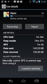
Battery Usage #
To find out how battery-friendly the two Android apps are, I check the
Battery Manager:

Comparison #
Google Latitude wins this one as well. InstaMapper keeps the GPS radio running almost constantly, whereas Google Latitude manages to sip radio access. I'm guessing that it uses WiFi, cell towers, and other non-GPS sources where possible.
Without these power consumption improvements, InstaMapper's GPS Tracker uses an order of magnitude more energy than Google Latitude. Ouch.
First Impressions #
After a day of persistent location tracking with both Google Latitude and InstaMapper, Google Latitude wins hands-down. It's easy to install, it provides simple and secure data access via oauth2client, and it preserves battery life nicely.